
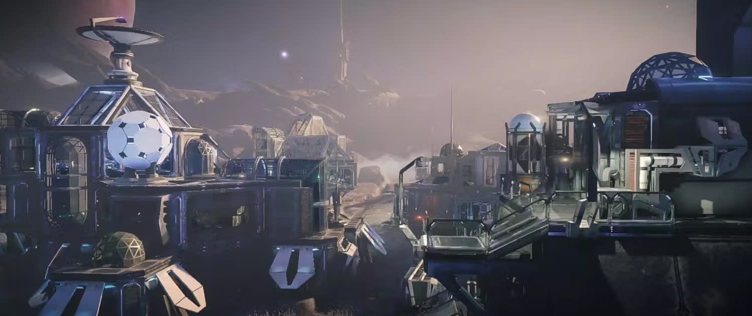


World Map Strategy Kit 2 is a powerful game toolkit for creating strategy games based on real or fictional world map.Build a real or fictional world for your strategy game in minutes, not months. World Map Strategy Kit 2 (WMSK) ships with ready-made cartography, unit movement, fog of war and pathfinding so you can skip the hard plumbing and go straight to your gameplay.Whether you're making a Risk-style conquest game, a grand-strategy sim or a global RTS, WMSK gives you a polished, interactive world map on day one.*** THE WORLD, READY TO USE ***Real-world WGS84 cartography out of the box: +240 countries, +4400 provinces and +7100 cities, with capitals and regional cities pre-classified.Standard country codes included (FIPS 10-4, ISO A2/A3/N3), so your data hooks in cleanly.Fully offline, no internet connection required.Several Earth textures and styles from 2K up to 16K High-Res.Online and Offline map tiles system supporting zoom up to street level. Includes cache and tile downloader assistant. Supports integration with OpenStreetMap, CyclOSM, Stadia Maps, Carto, Wikimedia, ThunderForest, OpenTopoMap, Google Maps (Satellite & Relief), MapBox, MapTiler, ESRI, USGS and Xweather services out of the box (service may require special license). Ability to connect to custom tile servers.*** 4 VIEW MODES, ONE ASSET ***Flat map in 3D, flat map in 2D (as a UI element), a custom 3D viewport with relief, and Unity terrain mode (projects the map onto standard terrain).Exclusive 3D surface viewport with real-time customizable height, infinite horizontal scrolling (world wrap) and PBS-based effects: water, coast foam, buoyancy, frontier lines and more.Switch smoothly between 2D and 3D viewport at runtime; optional curved map mode and minimap.*** BRING THE MAP TO LIFE ***Artistic, animated fog of war with a one-call API to clear fog over a zone, country or province.Animated, thick, smooth country borders with custom color, width and patterns.Cloud layer with animated drop shadows, plus an optional day/night cycle.Dynamic country and province labels that adapt to the terrain, with smart placement and curved text via TextMesh Pro.Draw animated dashed routes, throwing arcs and on-terrain paths; add scrolling or blinking tickers/banners over the map.*** MOVE UNITS AND FIGHT FOR TERRITORY ***A* pathfinding for unit movement: assign terrain capabilities and units automatically take the optimal route.Compute paths by world position, country-to-country (Risk style), province-to-province or hexagonal grid cells.Per-cell or per-edge crossing costs, roads, and a low-vertex hexagonal grid you can color, texture and animate (blink, flash, fade).Highlight and select countries and provinces, fly to any location at custom speed and zoom, follow units with the camera, and rectangle-select with click & drag.Merge/conquer map regions at runtime; define Mount Points (landmarks with location, type and custom attributes) for placing units, buildings and control zones.*** CREATE AND EDIT YOUR OWN MAPS ***Built-in Map Editor to create or modify countries, provinces and cities, plus a territories importer that builds frontiers from color textures.Map Generator: produce random world maps (borders, cities, names, heightmaps, water masks and more) from a few sliders and buttons.Recolor, retexture or fill any country/province and change water/fog colors at design time or runtime.*** BUILT FOR DEVELOPERS ***Clean, documented C# API for positioning, selecting and moving units (by lat/lon, 2D coordinates or country/province/city name).One line of code to move units honoring terrain type (water, land, air), costs and elevation constraints.Custom attributes (with JSON support) for countries, provinces, cities, mount points, grid cells and units; lat/lon to plane converter included.*** PROVEN AND COMPLETE ***100% C# source code included.+90-page manual, 50+ demo scenes, plus YouTube tutorials and sample videos.Compatible with Built-in and URP pipelines.Compatible with Unity 2022.3 and Unity 6, including Render Graph.Get a working world map today and spend your time on the game, not the map. See the comparison table to pick the right map asset for your project.Related Assets:- World Map Strategy Kit is included in the World Maps Pro Bundle 2.- World Flags and Weather Symbols is a convenient package with countries flags.- Military Units 3D contains many units for RTS/war games.📖 Documentation | 💬 Support | 🎬 YouTube | 🏢 Publisher PageKronnect is dedicated to high-quality Unity assets with continuous updates and responsive support.
World Map Strategy Kit 2 は、現実または架空の世界地図に基づいて戦略ゲームを作成するための強力なゲーム ツールキットです。
説明
World Map Strategy Kit 2 (WMSK) は、現実または架空の世界地図に基づいて戦略ゲームを作成するための強力なゲーム ツールキットです。 ゲームの開発において AAA キックスタートを提供するために実装するのが複雑な、視覚的に魅力的な優れた機能が含まれています。
*** ビジュアル機能 ***
- 4 つのメイン ビュー モード: 3D のフラット マップ、2D のフラット マップ (UI 要素)、レリーフ付きのカスタム 3D ビューポート、Unity テレイン モード (標準のテレインにマップ フィーチャを投影)。
- カスタマイズ可能な/リアルタイムの高さ、無限の水平スクロール (ワールド ラップ)、豪華な効果 (水、海岸の泡、浮力効果、フロンティア ライン、PBS ベースなど) を備えた地形用の 3D サーフェス メッシュを備えた独自のカスタム ビューポート
- 2K から 16K の高解像度まで、いくつかの地球の背景テクスチャとスタイルが含まれています。
- 地形上にドロップ シャドウがアニメーション化されたクラウド レイヤー。
- シンプルなAPIを使用した芸術的でアニメーション化された戦争の霧は、支配地域、国、または州の霧を一掃します。
- アニメ化された / 太い / 滑らかな国境! サンプル テクスチャを使用するか、カスタムの色、幅、パターンを使用して独自のテクスチャを追加します
- カーブマップモード。
- 昼夜サイクル。
- 素早いナビゲーションのためのオプションのミニマップ。
- 2D と 3D ビューポート モード間のスムーズなランタイム切り替え
- 地形に適応するテキストを含む動的な国および州のラベル。
- TextMesh Pro を使用した曲線テキストによるスマートな国ラベル配置アルゴリズム!
- アニメーション化された破線をサポートする線描画システムで、ルート、投げるアーク、地形上の経路などを表示できます...
- ティッカー/バナーのサポート。 地図上にスクロール/点滅メッセージを簡単に追加できます。
*** マップの特徴 ***
✔ オフライン機能 (インターネット接続は必要ありません):
- WGS84 データムの現実世界の地図作成が国と州に含まれています。 国別 FIPS 10-4、ISO A2、A3、および N3 標準コードが含まれています。
- +4,400 の州、+7,100 の都市、+240 の国のフロンティアが含まれます。 ハイスケールとロースケールの国のフロンティア。
- 都市は、通常の都市、地方および国の首都に分類されます。
✔ ストリート レベルまでのズームをサポートするオンラインおよびオフライン マップ タイル システム。 キャッシュとタイル ダウンローダー アシスタントが含まれています。 OpenStreetMap、Stamen、Carto、Wikimedia、ThunderForest、OpenTopoMap、MapBox、Sputnik、AerisWeather サービスをすぐにサポートします (サービスには特別なライセンスが必要な場合があります)。 カスタム タイル サーバーに接続する機能。
*** その他のマップ機能 ***
- 国、州、都市を作成または変更するためのマップ エディター。これには、カラー テクスチャに基づいてフロンティアを自動的に作成するテリトリー インポーター ツールが含まれます。
- マップ ジェネレーター: いくつかのスライダー、オプション、ボタンを使用して、国や州の境界、都市、ランダムな名前、テクスチャ (高さマップ、背景テクスチャ、ウォーター マスクなど) を含むランダムな世界地図を作成します!
- 必要に応じてマップをカスタマイズします: テクスチャや水/霧の色を変更したり、州や国にテクスチャを追加したり、それらを色で塗りつぶしたりします...設計時または実行時に。
- マウント ポイントのサポート。 マップ上の場所、タイプ、カスタム属性を使用して独自の戦略/ランドマークを定義し、ゲーム中にユニット、建物、コントロール ゾーンなどを配置するためにそれらを簡単に使用できます。
- 実行時にマップ領域をマージ/征服します。
*** グリッドとパス検索機能 ***
- 少ない頂点数と最高のフレーム レートに最適化された六角形のグリッド。 任意のセルに色/テクスチャを適用します。 まばたき、フラッシュ、フェードアウトなどのセル効果。
- ユニット移動用の A* アルゴリズムに基づく経路探索エンジン。 地形能力をユニットに割り当てると、ユニットは自動的に最適な経路をたどります。 パスは、世界の位置、国から国へ (リスク スタイル)、州から州へ、または六角形のグリッド セル (古典的な戦略ゲーム) に基づいて計算できます。
- セルごとまたはエッジごとのセル交差コストを定義します。
- 道路。
*** インタラクション機能 ***
- 完全にインタラクティブなマップとタッチ対応: ズーム、パン、スクロール、ピンチしてズームなど
- 国と地域を選択するための強力な強調表示システム。
- カスタム速度とズームレベルで、任意の国、州、都市、場所に飛びます。 特定の国/州/地域へのズームを閉じて、画面全体に拡大します。
- マップ上の任意のユニットにカメラを自動的に追従させます。
- 無限スクロール オプション (ワールド ラップ)
- 長方形の選択。 クリック アンド ドラッグして四角形を描き、ユニットを選択します。
*** 開発者向け機能 ***
- マップ上でのユニットの配置、選択、および移動のための使いやすく文書化された API (緯度/経度、平面/2D 座標、または国/州/都市名に基づく場所)。
- 地形能力 (水、陸、空ユニット)、地形コスト、標高の制約などに従ってマップ上でユニットを移動するための 1 行のコード。
- 国、州、都市、マウント ポイント、グリッド セル、ゲーム ユニットのカスタム属性。 JSON のサポート。
- 電卓。 緯度/経度から平面座標に、またはその逆に変換します。
- 包括的なドキュメント (91 ページのマニュアル)。
- 42 のデモ シーンと主要な機能を示す Youtube チュートリアルとサンプル ビデオ。
- 100% C# ソースコードを含む