







New Zealand Volcanic Plateau Real-World Terrains 260 km²
Matei Ioan Alexandru
$15.39
$21.99
30%OFF
(no ratings)
Jump AssetStore
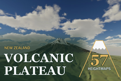
57 maps of New Zealand's volcanoes and volcanic plateau, 260 km² each at 8 m - Ruapehu, Taranaki and lava domes as true-scale Unity terrains.Unity 2022.3 and above. Built-in, URP and HDRP in one package. Real-scale terrains (1 unit = 1 m) built from the exact heightmap pixels.▶ Full 4K video showcase: https://youtu.be/LFFEIppgISAThe volcanoes and volcanic plateau of New Zealand at their real size - 57 maps, 16 x 16 km eachSnow-capped stratovolcanoes above their ring plains, lava domes beside lakes, caldera rims and wide ignimbrite uplands cut by river gorges. Every map is a 260 km² square of real ground from elevation data (DEM) at 8 m per pixel, with 179 m to 2,253 m of relief, built in Unity sample for sample.✦ ON THE PLATEAU57 volcanic heightmaps - 16-bit PNG, 2017 x 2017 px; size and height range in each file name and inside the PNGTrue-scale terrains - each map becomes one Unity terrain of 2049 samples from the original pixels, 1 unit = 1 metreThree demo levels - Ruapehu Summit Plateau, Taranaki Cone and Volcanic Dome and Lakes, each in Built-in, URP and HDRP (9 scenes)Lake water - clear blue-green lakes at the foot of the dome, found in the elevation data - the terrain heights stay exact✦ GROUND FOR EVERY MAPEight 4K layers - tussock grassland, green pasture, native bush, scree, rock, river gravel, snow and volcanic scoriaA painter that reads the land - pasture on the ring plains, bush in the gullies, scoria and ash on the upper cones, snow on the summitsAny terrain, one click - Tools > Lidar Terrains > New Zealand Ground paints the other 54 maps - or your own terrain - like the demo levelsNo tiles, no seams - hex-tile sampling at three scales and four scales of variation keep wide tussock plains free of repeats✦ FRAME RATES AT 4K3840 x 2160, no upscaling - HDRP 124-149 FPS · URP 142-164 FPS · Built-in 236-284 FPS in player builds on an RTX 3090✦ SET UP IN A MINUTEUnity 2022.3 and above. Tools > Lidar Terrains > Project Setup turns on terrain holes for your pipeline. Built-in has no post-processing, so its demo levels look plainer than URP and HDRP.✦ MADE FOROpen-world and survival games, flight and helicopter simulators, volcanic adventure maps and cinematic establishing shots.✦ MORE OF NEW ZEALANDRanges & Hill Country - bush-clad ranges and green hills - https://assetstore.unity.com/packages/slug/428790Southern Alps - snowy peaks and braided rivers - https://assetstore.unity.com/packages/slug/428792Southern Lakes & Ranges - glacial lakes and tussock ranges - https://assetstore.unity.com/packages/slug/428794Heightmaps - 57 maps, 16-bit greyscale PNG, 2017 x 2017 px, 8 m per pixel (16.13 x 16.13 km, 260 km²)Relief - 179 m to 2,253 m; the lowest point of every map sits at 0Terrains - one Unity terrain of 2049 samples per map; terrain holes trim the unused edgePrecision - 5.5 mm (lowest relief) to 68.8 mm (highest relief) per height levelDemo - 3 prefabs that work in every pipeline, 9 scenes, lake water on the dome mapGround - 8 early-summer layers + shared layers, 4096 x 4096 albedo/smoothness, normal and maskPainter - bush and snow lines, sun side, ribs and gullies, drainage, lake beds and scoria from the terrain shape; any terrain, restore buttonShaders - world-aligned hex-tile terrain shaders with side projection, tussock tufts, bush crowns and fine relief - Built-in, URP, HDRPTools - Terrain Builder, Project Setup, New Zealand Ground painter, PDF manualUnity - 2022.3 and above