



Queen Elizabeth Islands Fjords & Coasts Real-World Terrains 264 km²
Matei Ioan Alexandru
$19.24
$27.49
30%OFF
(no ratings)
Jump AssetStore
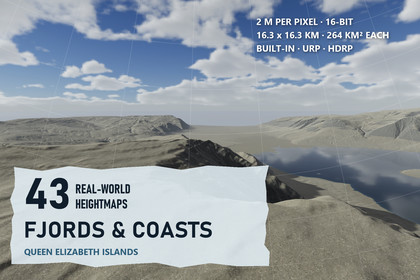
43 High Arctic fjord and coast maps from Nunavut at 2 m, 16.3 km square each, real scale in Unity - sea cliffs, sea ice and open fjords. Built-in/URP/HDRP.Unity 2022.3 and above. Built-in, URP and HDRP content in one package; open Tools > Lidar Terrains > Project Setup once to enable terrain holes for your pipeline.▶ Watch the coast in 4K: https://youtu.be/DSDcu2QhXrkHigh Arctic coast at its real size - 43 maps of fjords, sea cliffs and frozen bays from the Queen Elizabeth Islands, NunavutFjord walls rising from cold sounds, ice caps that end in cliffs above the sea, fjord heads choked with summer sea ice, and coastal lowlands cut by braided streams. Every map is a 16.26 x 16.26 km square of real coast (264 km²) from LiDAR elevation data at 2 m per pixel, with 271 m to 1,331 m of relief, built in Unity sample for sample.✦ ON THE COAST43 coastal heightmaps - 16-bit PNG, 8129 x 8129 px; size and height range are written in each file name and inside the PNGTrue-scale terrains - each map becomes 2 x 2 Unity terrains of 4097 samples, made from the original pixels, 1 unit = 1 metreThree coastal demo levels - Ice Cap Coast, Mountain Fjord and Fjord Head, each ready in Built-in, URP and HDRP (9 scenes)Frozen bays and open fjords - summer sea ice with melt ponds painted where the bays are frozen; Shore Water where Mountain Fjord is openTerrain Builder - turns any of the 43 heightmaps into its own real-scale terrain with one click✦ A COASTAL GROUND LOOKEight 4K layers - frost-shattered coast gravel, lichen crust, tidal silt, shale talus, bedded cliff rock, beach shingle, late snow and sea iceRead from the shape of the coast - slope finds the cliffs and their talus, height above the sea finds the tidal flats and raised beaches, drainage finds the stream bedsCliff beds - each demo map carries its own bed table, so sea cliffs show soft bands of sedimentary colourNo repeats, no seams - hex-tile sampling at three scales and broad colour variation on top, from a walker's eye up to a full flight✦ FRAME RATES AT 4K3840 x 2160, no upscaling - HDRP 115-128 FPS · URP 98-139 FPS · Built-in 155-278 FPS in player builds on an RTX 3090✦ SET UP IN A MINUTEUnity 2022.3 and above. Tools > Lidar Terrains > Project Setup turns on terrain holes for your pipeline; Shore Water Setup switches on what the water needs. Built-in has no post-processing, so its demo levels look plainer than URP and HDRP.✦ MADE FORPolar expedition and survival games, sailing and flight simulators, open-world coastlines, cinematics and terrain research. The PNGs also open in any tool that reads 16-bit heightmaps.✦ INLAND FROM THESE COASTSMountains & Ridges - folded ranges and a valley glacier - https://assetstore.unity.com/packages/slug/427612Ice Caps & Plateaus - the ice caps that feed the coastal glaciers - https://assetstore.unity.com/packages/slug/427614Polar Desert Lowlands - the dry plains and tundra lakes - https://assetstore.unity.com/packages/slug/427616None of these maps covers ground already sold in another pack of this seller.Heightmaps - 43 coastal maps, 16-bit greyscale PNG, 8129 x 8129 px, 2 m per pixel (16.26 x 16.26 km, 264 km²)Relief - 271 m to 1,331 m; the lowest point of every map sits at 0Terrains - 2 x 2 Unity terrains of 4097 samples per map; terrain holes trim the unused edgePrecision - 8.3 mm (lowest relief) to 40.6 mm (highest relief) per height levelDemo - 3 prefabs that work in every pipeline, 9 scenesGround - 8 Fjords and Coasts layers + shared layers, 4096 x 4096 albedo/smoothness, normal and maskSea ice and water - melt-pond sea ice on the terrain; Shore Water surfaces with depth colour where a fjord is openShaders - world-aligned hex-tile terrain shaders with side projection, cliff beds and fine relief - Built-in, URP, HDRPTools - Terrain Builder, Project Setup, Shore Water Setup, Arctic Ground Textures, PDF manualUnity - 2022.3 and above