



Queen Elizabeth Islands Mountains & Ridges Real-World Terrains 264 km²
Matei Ioan Alexandru
$19.24
$27.49
30%OFF
(no ratings)
Jump AssetStore
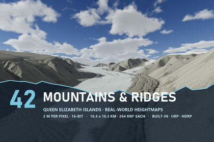
Folded ridges, glacier valleys and escarpments: 42 Canadian Arctic mountain maps at 2 m, 264 km² apiece, exact Unity terrains for Built-in, URP and HDRP.Works in Unity 2022.3 and above with the Built-in Render Pipeline, URP and HDRP. The Project Setup window turns on terrain holes in the active pipeline asset.▶ See the ranges in a 4K flight: https://youtu.be/hxsORYrk_QE42 mountain maps from the Canadian High Arctic - folded ridges, glacier valleys and limestone escarpments, at 2 m per pixelThe ranges of the Queen Elizabeth Islands, made from LiDAR elevation data: long ridges of bedded rock folded into parallel waves, peaks rising above a valley glacier, gullied hills and escarpments over broad valley floors. Up to 1,951 m of relief on a single map; each map covers 16.26 km on a side (264 km²).✦ WHAT YOU GET42 heightmaps - 16-bit PNG at 8129 x 8129 px, from 512 m to 1,951 m of reliefExact Unity terrains - 2 x 2 tiles of 4097 samples per map with no resampling; one height level is 15.6 to 59.5 mmGlacier Valley Peaks, Folded Ridges, Escarpment Valley - the demo levels, each in Built-in, URP and HDRPA glacier with a firn line - white firn above, bare grey-blue ice below and moraine bands along the flow, on Glacier Valley PeaksVerify - compares the built terrain with every original pixel✦ MOUNTAIN GROUND4K layers for rock and gravel - frost gravel, moss crust, valley silt, limestone talus, bedded limestone, outwash gravel, snowfields and glacier iceLimestone beds - level bands of paler and darker rock on the cliffs and ridge crests, from a bed table per demo mapTalus where it belongs - the scree follows the steep slopes below the cliffs; outwash gravel spreads over the valley floorsSnow in the right places - late snow stays in the lee hollows and north-facing gullies, not as random spotsClean steep faces - side projection keeps cliff textures sharp instead of stretched✦ MEASURED AT NATIVE 4KRTX 3090, player builds - HDRP 110-133 FPS · URP 114-156 FPS · Built-in 227-364 FPS✦ REQUIREMENTSUnity 2022.3 and above, with Built-in, URP and HDRP content in one package. The Project Setup window enables terrain holes in your pipeline asset. The Built-in demo levels have no post-processing and look simpler than URP and HDRP.✦ GOOD FORMountaineering and survival games, hiking and flight simulators, open-world ranges, film backdrops and studies of glacial landforms.✦ THE REST OF THE ISLANDSFjords & Coasts - where the valleys meet the sea - https://assetstore.unity.com/packages/slug/427610Ice Caps & Plateaus - the high ice above the ranges - https://assetstore.unity.com/packages/slug/427614Polar Desert Lowlands - the low plateaus and plains - https://assetstore.unity.com/packages/slug/427616Every map here shows ground this seller sells in no other pack.Maps - 42 x 16-bit PNG heightmaps at 8129 x 8129 px; every map 16.26 km square (264 km²) at 2 m spacingHeight span - 512 m to 1,951 m per map, minimum at 0Unity terrains - four 4097-sample tiles per map, holes cut along the outer edgeOne height level - 15.6 mm on the lowest-relief map, 59.5 mm on the highestDemo content - 9 scenes (3 per pipeline) and 3 pipeline-independent prefabsTextures - Mountains and Ridges look with 8 layers plus the shared ones, 4K albedo/smoothness, normal, maskGlacier - firn and bare ice with moraine bands, painted on the terrainRendering - anti-tiling terrain shaders, steep-face side projection, limestone beds - Built-in, URP and HDRPWater - Shore Water included for your own scenes (the demo maps have no open water)Editor - Terrain Builder, Project Setup, Shore Water Setup, Arctic Ground Textures; documentation as PDFCompatibility - Unity 2022.3 and above