



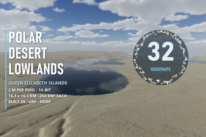
Queen Elizabeth Islands Polar Desert Lowlands Real-World Terrains 264 km²
Matei Ioan Alexandru
$19.24
$27.49
30%OFF
(no ratings)
Jump AssetStore
Nunavut's polar desert, ready to walk: gorges, terraces, patterned flats and tundra lakes on 32 lowland maps. Fine 2 m data; three render pipelines.Supports Unity 2022.3 and above in Built-in, URP and HDRP. After import, Project Setup enables terrain holes and Shore Water Setup the depth and opaque textures for the lakes.▶ Fly over the lowlands in 4K: https://youtu.be/swDxd55NWj0The polar desert of Nunavut in Unity - 32 lowland maps of plateaus, gorges, terraces and tundra lakesLow plateaus cut by branching valleys, gorges in flat-lying sandstone, terraced valley sides and lake plains near the sea, from the Queen Elizabeth Islands. LiDAR elevation data at 2 m per pixel keeps the gentle forms of the plains: one height level is only 5.6 to 25.8 mm. Each map covers 16.26 x 16.26 km (264 km²) with 184 m to 845 m of relief.✦ INCLUDED32 lowland heightmaps - 16-bit PNG, 8129 x 8129 px, north upUnity terrains from the exact pixels - 2 x 2 tiles of 4097 samples per map, unused edge strip cut with terrain holesPlateau Gorge, Terraced Plateau, Lake Plain - 9 demo scenes across Built-in, URP and HDRPLakes and a sea inlet - Shore Water on Lake Plain, coloured by its real depthTerrain Builder - one click from any of the 32 PNGs to a real-scale terrain✦ POLAR DESERT GROUNDEight 4K layers - bare desert pavement, crust soil, silt flats, sandstone talus, sandstone, raised-beach shingle, late snow and patterned groundPatterned ground - on the level, poorly drained flats away from the streamsSandstone beds - plateau edges and gorge walls take the colours of flat-lying bedsFine relief up close - small lumps and hollows below the 2 m data on the near ground, fading with distance✦ PERFORMANCEPlayer builds at 3840 x 2160 - HDRP 107-151 FPS · URP 94-174 FPS · Built-in 146-444 FPS on an RTX 3090, no upscaling✦ UNITY 2022.3 AND ABOVEBuilt-in, URP and HDRP in one download; Project Setup enables terrain holes, Shore Water Setup the depth and opaque textures. Built-in demo levels have no post-processing.✦ IDEASRover and expedition games, arctic survival, driving and walking simulators, wide open-world plains and science visualisation.✦ OTHER LANDSCAPES OF THE ISLANDSFjords & Coasts - sea cliffs and frozen bays - https://assetstore.unity.com/packages/slug/427610Mountains & Ridges - high ranges and a valley glacier - https://assetstore.unity.com/packages/slug/427612Ice Caps & Plateaus - domes of ice and outlet glaciers - https://assetstore.unity.com/packages/slug/427614No ground in this pack appears in any other pack of this seller.Heightmap files - 32 PNGs, 16-bit, 8129 x 8129 px, 2 m per pixel, 16.26 km per sideRelief - 184 m to 845 m per mapBuild - every map as 2 x 2 Unity terrains of 4097 samples, exact pixel values, holes on the unused stripHeight resolution - 5.6 mm to 25.8 mm per levelDemo - Plateau Gorge, Terraced Plateau and Lake Plain - 9 scenes, 3 prefabsGround layers - 8 Polar Desert Lowlands layers + shared ones; 4K albedo/smoothness, normal and maskLakes - Shore Water surfaces for the lakes and the sea inlet of Lake PlainTerrain shaders - stochastic hex tiling, steep-face projection, sandstone beds, fine relief; Built-in, URP, HDRPEditor windows - Terrain Builder, Project Setup, Shore Water Setup, Arctic Ground Textures; PDF manualSupported - Unity 2022.3 and above