



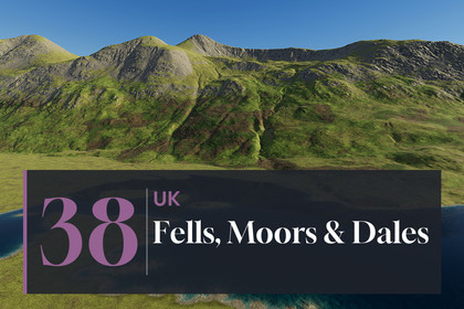
UK Fells, Moors & Dales Real-World Terrains 25 km²
Matei Ioan Alexandru
$15.39
$21.99
30%OFF
(no ratings)
Jump AssetStore
38 real-world maps of English fells, moors and dales, 5 x 5 km (25 km²) each at 1.24 m, true 1:1 scale. 9 demo scenes, Built-in/URP/HDRP.Unity 2022.3 and above. Built-in, URP and HDRP in one package. Real-scale terrains (1 unit = 1 m) built from the exact heightmap pixels.▶ Full 4K video showcase: https://youtu.be/FxTHshhxeUsThe fells, moors and dales of England and the Scottish Border - Lake District fells and lakes, Pennine and North York moors with reservoirs, the Peak District, Bleak Law and Kielder, and lowland Cornwall and Cambridgeshire - at their real size, 5 x 5 km per map at 1.24 m38 maps of the fells, moors and dales of England and the Scottish Border from real-world elevation data (DEM). Lake District fells above long lakes, Pennine and North York moors with peat, heather and reservoirs, Peak District edges and dales, Bleak Law and Kielder Water, and the lowlands of Cornwall and Cambridgeshire - 1.24 m between samples. Each map covers 5.00 x 5.00 km (about 5 x 5 km, 25 square km) at 1.24 m between samples. Every Unity terrain sample is an original heightmap pixel - nothing is stretched or resampled - and 1 Unity unit is 1 metre.✦ WHAT'S INSIDE38 heightmaps - 16-bit PNG, 4033 x 4033 px, relief from 51 m to 778 m per mapOne Unity terrain per map - 4097 samples at the map's own 1.24 m spacing; the unused 64-sample strip at the edge is cut away with terrain holes3 demo levels x 3 render pipelines - 9 ready scenes to fly or walk through: Lakeland Fells, Pennine Moor Reservoirs, Moorland DaleTerrain Builder - one click turns any heightmap into a real-scale Unity terrain3 ground looks - 8 ground layers each in 4K (Lakeland Fells: meadow, forest floor, dry earth, scree, rock, gravel, bracken, lake bed; Pennine Moorland: meadow, forest floor, dry earth, scree, rock, gravel, heather, lake bed; Lowland and Heath: meadow, forest floor, dry earth, scree, rock, gravel, heath, lake bed)Shore water - transparent lakes of the Lake District and moorland reservoirs: clear at the shoreline, the bed visible in the shallows, darker water further out, rivers that follow the valley downhill, a thin moving shore film and wet ground just above the water, in Built-in, URP and HDRPSummer in the hills - the ground of the demo levels is painted from the real shape of each map: valley pasture, bracken slopes and fell grass up to the crags and scree of the Lake District; heather, moor grass, bare peat and plantations on the Pennine moors; fields, copses and heath in the lowlands✦ FEATURESHuge real-world maps - 5 x 5 km of real ground in every map, at 1.24 m between samples: crags, scree, becks, peat hags, gritstone edges, dales, field walls and reservoir dams are in the data itselfExact scale - size and height range are in every file name and inside every PNG, and the builder reads them for youAnti-tiling terrain shaders - every layer blends three texture sizes by viewing distance, so no repeating patternsCliffs without stretching - textures are projected from the side on steep faces, so walls show real rock texture instead of vertical streaks; flat ground is unchangedVerify - compares every terrain height with the original pixels✦ PERFORMANCENative 3840 x 2160 - no upscaling, demo scenes in player builds: HDRP 92-209 FPS · URP 107-346 FPS · Built-in 303-811 FPS (RTX 3090)✦ DEMO CONTROLSMouse look · WASD move · Shift fast · G walk at 1.8 m eye height · F fly · N / P next / previous level · H help✦ UNITY 2022.3 AND ABOVEBuilt-in, URP and HDRP in one package. Tools > Lidar Terrains > Project Setup switches on terrain holes, and Shore Water Setup the depth and opaque textures the water reads, in your pipeline asset with one click. The Built-in Render Pipeline has no post-processing, so the Built-in demo levels look simpler than the URP and HDRP ones.✦ USE CASESOpen-world games · flight and driving simulators · hiking, hunting and survival games · cinematics · terrain studies. The heightmaps also work in other tools: 16-bit PNG, north up, size and height range in the file name.✦ MORE REAL-WORLD TERRAINSSame format, same tools:Alaska Mountain Peaks - https://assetstore.unity.com/packages/slug/425664Alaska Valleys & Uplands - https://assetstore.unity.com/packages/slug/425668Alaska Fjords, Lakes & Volcanoes - https://assetstore.unity.com/packages/slug/425670British Columbia Alpine Peaks - https://assetstore.unity.com/packages/slug/425040British Columbia Mountain Valleys - https://assetstore.unity.com/packages/slug/425042British Columbia Lakes & Rivers - https://assetstore.unity.com/packages/slug/425044British Columbia Plateau & Eskers - https://assetstore.unity.com/packages/slug/425046Heightmaps - 38 x 16-bit greyscale PNG, 4033 x 4033 px: 38 maps of 5.00 x 5.00 km (about 5 x 5 km, 25 square km) at 1.24 m per pixelRelief - 51 m to 778 m per map (lowest point of each map at 0)Unity terrains - one terrain of 4097 samples per map, terrain holes for the exact edgeHeight precision - one height level is about 0.2 cm on the flattest map and about 2.4 cm on the map with the largest height rangeDemo content - 3 map prefabs (one prefab works in every pipeline) + 9 demo scenes (3 per pipeline)Ground textures - Lakeland Fells + Pennine Moorland + Lowland and Heath (24 ground layers) + the shared ground layers, 4096 x 4096 albedo, normal and maskWater - transparent lake and river surfaces whose colour comes from the real water depth (depth texture), soft shorelines, travelling waves and river flow, for Built-in, URP and HDRPShaders - anti-tiling, world-aligned terrain shaders with side projection on steep faces (triplanar) for Built-in, URP and HDRPEditor tools - Terrain Builder, Project Setup, USA and UK Ground Textures; PDF documentation includedCompatibility - Unity 2022.3 and above; Built-in, URP and HDRP