


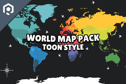
Build rich interactive maps with this Toon Style World Map Pack which includes countries, u.s. states, continents, and props. Ideal for games, education, and visualization.This asset is designed exclusively for the Universal Render Pipeline (URP). Compatible with Unity 2022.3 LTS, Unity 6 LTS, or newer versions.🌍 Toon Style World Map PackA stylized low-poly world map designed for strategy, simulation, education, and interactive projects. Built with a clean, modular structure that gives you full control over every region directly inside Unity.Includes countries, continents, detailed U.S. states with counties, Canadian provinces, and more — all optimized and ready to use.■ Key Features ■Modular hierarchy-based design (full control per region)Easily change colors, materials, or visibility of individual regionsOptimized for performance (mobile & desktop)URP-ready materialsDrag-and-drop prefabs for fast setupDual formats: 2D (data visualization) & 3D (immersive scenes)🗺️ Included ContentAll continents and countriesAll 50 U.S. states with 3,000+ county outlines (2024)All 13 Canadian provinces and territoriesAll 8 Australian states and territoriesCapital city markers (U.S., Canada, & Australia)144 organized models and prefabs⛔ Important NoteAll maps are designed as separate models and levels of detail. They are not intended to perfectly overlay or transition seamlessly with one another.Most implementations will switch between map levels (e.g., world → region → detail) rather than blend them together.Each region is individually organized in the hierarchy, allowing full customization such as changing colors, materials, or enabling/disabling specific areas.📦 Additional InfoIncludes:Documentation.pdf📬 Contact & UpdatesFollow for updates, promotions & previews:X (Twitter) | InstagramFor support or questions, contact:contact@hqpstudio.com⚙️ GeneralUV Mapping: Optimized using a color atlas workflowTextures: 1 × 256×256 PNG (atlas)Materials: URP compatibleDemo Scene: Included for quick setup and preview3D World Map• Minimum Polycount: 34,408 tris• Maximum Polycount: 53,592 tris2D World Map• Minimum Polycount: 8,489 tris• Maximum Polycount: 12,949 tris3D United States | Canada | Australia• Minimum Polycount: 4,076 tris• Maximum Polycount: 18,785 tris2D United States | Canada | Australia• Minimum Polycount: 993 tris• Maximum Polycount: 4,968 tris3D United States Counties• Minimum Polycount: 880 tris• Maximum Polycount: 21,140 tris2D United States Counties• Minimum Polycount: 212 tris• Maximum Polycount: 5,120 tris3D Map Props• Minimum Polycount: 134 tris• Maximum Polycount: 1,988 tris2D Map Props• Minimum Polycount: 33 tris• Maximum Polycount: 497 tris